Puerto Vallarta is known for its golden beaches, jungle-covered mountains, and unforgettable sunsets. It’s one of Mexico’s most beloved coastal destinations—and for good reason. But while visitors and residents are often prepared for sun and surf, there’s one natural hazard that doesn’t get much attention: tsunamis.
How real is the risk? Could a large earthquake off the coast send waves toward the bay? And if so, would there be time to react? In this article, we break down what scientists have discovered about Puerto Vallarta’s tsunami vulnerability, why it hasn’t been widely discussed, and what every traveler or property owner should know to stay safe. If you’re also curious about seismic activity in the region, check out our full guide on earthquake risks in Puerto Vallarta.
- Puerto Vallarta’s Location and Tectonic Setting
- Has Puerto Vallarta Ever Experienced a Tsunami?
- Does the bay protect Puerto Vallarta?
- What Does Science Say About Tsunami Risk in Puerto Vallarta?
- Why Haven’t We Heard More About This?
- What Travelers and Residents Should Do
- Final Thoughts
- Sources & Further Reading
Puerto Vallarta’s Location and Tectonic Setting
Puerto Vallarta sits along Bahía de Banderas, a deep coastal bay formed by tectonic activity. It lies on the Jalisco Block, where two tectonic plates—the Rivera and the Cocos—subduct beneath the North American plate. This plate boundary is one of the most seismically active zones in Mexico, making the region vulnerable to large earthquakes and, under certain conditions, tsunamis.
Has Puerto Vallarta Ever Experienced a Tsunami?
Historical Tsunami Events in the Region
- 1932 Jalisco-Colima Earthquake (Mw 8.1–8.2): Triggered a tsunami with waves over 15 meters in nearby coastal towns.
- 1995 Colima-Jalisco Earthquake (Mw 8.0): Produced tsunami waves of 5+ meters that affected several areas along the Pacific coast.
While Puerto Vallarta itself hasn’t seen major damage from a tsunami in recent decades, these nearby events show that the risk exists—and is being taken seriously by scientists today.
Does the bay protect Puerto Vallarta?
✅ What’s true about Puerto Vallarta’s bay offering protection
- Bahía de Banderas is one of the largest and deepest bays in Mexico, with a wide mouth that curves gently inward.
- This geography can diffuse wave energy, especially for distant or off-angle tsunamis, compared to straight, exposed coastlines.
- Historical data shows that Puerto Vallarta has never suffered a catastrophic tsunami, even when nearby coasts were affected (like in 1932 or 1995).
⚠️ But here’s the catch
- If the tsunami is caused by a local earthquake directly offshore (like in the modeled “Vallarta Gap” scenario), the bay’s shape may actually focus wave energy, not weaken it.
- In simulations, waves up to 3.7 meters (12 feet) could strike the downtown zone in just 19 minutes, with flooding reaching up to 5.6 meters above sea level and traveling 5 km inland.
- A bay does not block a tsunami. It may change the wave’s direction, speed, and intensity, but cannot prevent its arrival if the quake is close and strong.
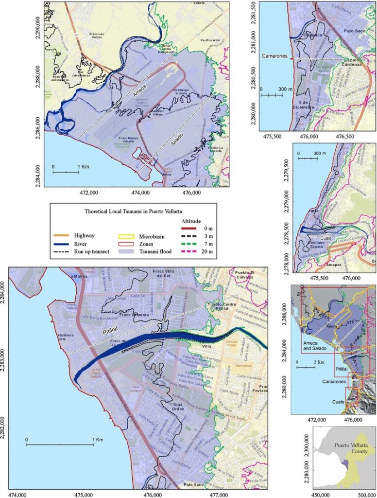
What Does Science Say About Tsunami Risk in Puerto Vallarta?
Simulation of a Hypothetical Mw 8.0 Earthquake
A 2022 peer-reviewed study simulated a major earthquake in the “Vallarta Seismic Gap” just offshore. Key findings:
- Tsunami Arrival Time: The first wave could reach central Puerto Vallarta (near the Cuale River) in just 19 minutes.
- Wave Height: Initial waves of approximately 3.7 meters (12 feet) could hit the coast.
- Flood Reach: Inland flooding could extend up to 5.6 meters above sea level, reaching as far as 5.1 kilometers inland in some low-lying areas.
- Most Affected Areas: The zone between the Ameca and Pitillal rivers, which includes hotel zones, the marina, and some residential areas.
These models are based on realistic tectonic scenarios, using historic earthquakes as a reference point.
Official Risk Rating
According to global disaster risk platform ThinkHazard.org, Puerto Vallarta is categorized as having a relatively high tsunami risk, with more than a 40% chance of a damaging event in the next 50 years.
Why Haven’t We Heard More About This?
Unlike places such as Hawaii or Indonesia, Puerto Vallarta hasn’t experienced a major tsunami in recent memory. That absence of recent impact has kept the issue off most travelers’ radars. However, the 2022 scientific risk assessment marked the first time Puerto Vallarta was studied in detail for local tsunami effects. Public infrastructure, hotel operators, and residents are beginning to take preparedness more seriously—but awareness is still growing.
What Travelers and Residents Should Do
- Map and practice evacuation routes.
- Use buildings with multiple floors for vertical evacuation when horizontal escape isn’t an option.
- Support natural barriers like mangroves and sand dunes that reduce tsunami wave energy.
Final Thoughts
| Factor | Details |
|---|---|
| Tectonic Activity | High – active subduction zone offshore |
| Historical Tsunamis Nearby | 1932 and 1995 events produced major waves |
| Modeled Impact | Waves ~3.7m high, flooding up to 5.6m inland |
| Time to Shore | First wave in ~19 minutes post-quake |
| Most Vulnerable Areas | Marina, Hotel Zone, Romantic Zone |
| Official Risk Rating | High (40%+ probability in 50 years) |
Puerto Vallarta may not be known as a high-risk tsunami zone, but the data tells a different story. The city’s location on a tectonic subduction zone, combined with recent scientific modeling, makes it clear: the risk is real, and it’s worth being prepared.
Whether you’re a tourist enjoying the beaches or a homeowner with a rental property, basic awareness and a simple evacuation plan can make all the difference in an emergency.